
Pisang Peak Climbing
 We combine this peak climbing with a world famous 'Annapurna Circuit' trekking.
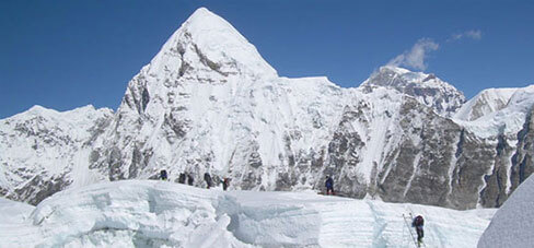
Pisang Peak is one of the non-expedition peaks in Nepal and rises opposite of Annapurna II (7937). Pisang Peak lies roughly in between the giants’ Annapurna I and Manaslu both eight thousand’s.
Pisang Peak rises above from Pisang village and yak pastures in a uniform slope of ice and snow to the final summit pyramid. This peak is considered as the easy climbing peak in Nepal. To reach the base camp from Pisang village, the path ascends through sparse wood and pasture to a Kharka at (4,380m) which is considered the best place for setting up the base camp. High Camp is set up at 5,400m climbing to a shoulder on the South-West Ridge. There will be snow at the high camp from the end of November to the end of March.
The well-defined ridge leads to the final snow slop, which is quite steep but not difficult to reach the summit. Descent is made on the same route.
This trek after all is difficult to match for its rugged mountain scenery, trekking challenges and the expose it provides on the variety of ethnic Nepalese cultures. Starting in the lowland paddy fields the trek steadily gains altitude passing through oak and pine forests and eventually emerging into high desert country at Manang (3597 m.). The descent is equally amazing and varied.
Strenuous trekking is well rewarded at both low and high altitudes, on the approach to the Thorung La (17,769 ft) as well as during the descent from it. Close up views of the Annapurna range (40 miles between the two river valleys contain at twelve 7000 m peaks and many more above the 6000m mark). Varied ecosystems, diverse cultures and an ever-changing landscape - lush, green paddy fields and oak forests, arid deserts and the deepest gorge in the world make this one of the most popular treks in the world.
Day 01: Arrive in Kathmandu. Transfer to Hotel.
Day 02: Full day guided sightseeing inside the Kathmandu Valley.
Join the welcome dinner with Live Nepali cultural progam we host. Hotel
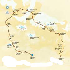
Day 03: Drive: Kathmandu / Besishar (760m / 5 hrs)
After breakfast you will board your private transport and start the drive to Dumre. This drive can take up to five hours and packed will be lunch provided. Your adventure vacation truly starts the moment you reach Besishar where your crew will be waiting for you. Your first day's stay will be at Besisahar. Camp
Day 04: Besisahar to Kuhdi (790m / 3 hrs)
Pass through the village of Besisahar and descend to the river valley. Crossing the river the trail climbs steeply and continues contouring in wet subtropical forests and paddy fields. The trail continues north above the Marsyangdi Khola towards Khudi Khola, a major tributary that drains the East End of the Lamjung Himal. Then, crossing suspension bridge to come back to the Marsyangdi Khola you reach the village of Khudi. Camp
Day 05: Khudi to Bhaunadanda (1310m / 4 hrs)
The changes in the valley's ecosystem and its physical characteristics become evident now. Himalchuli is the major summit to the east. Crossing the river to its east bank you pass through the village of Bhulbhule and heading north continue past Ngadi (930 m.) to the ridge top settlement of Bahundanda (1311 m.). The name of this village literally means "Brahmin Hill". Camp
Day 06: Bhaunadanda to Tal (1700m / 6 hrs)
Descend to the valley floor and then, crossing the river, climb steeply out of it to follow a trail beautifully carved out of the rock wall of the valley. Passing through Khani Gaoon and Ghermu you reach Sangye. Continue along the West Bank of the Marsyangdi River through the village of Jagat to Chamje where you will cross the river to its eastern bank to enter the Manang District at the village of Tal.
As you head upstream, you will begin to notice the changes in the people as well as the land, architecture and culture. You notice that there is a concentration of people of Tibetan origin, their houses are built of rock, the vegetation is less tropical and the culture is predominantly Tibetan. Camp
Day 07: Tal to Bagarchap (2160m / 6 hrs)
The trail from Tal crosses the Marsyangdi Khola to its West Bank after the village of Karte and continues towards the village of Dharapani. From Dharapani you continue up the river valley past the Gurung village of Thonje to the village of Bagarchap. Bagarchap means "Butcher's place". Camp
Day 08: Bagarchap to Chame (2670m / 7 hrs)
Continuing along the left bank, climb up the heavily wooded Manang Valley past small settlements with excellent views of Manaslu and the peaks above Larkya La. Lodge at the village of Chame, administrative headquarters of the region and the last major market before Jomosom. Chame also has a police check post and bank. Camp
Day 09: Chame to Pisang (3300m / 6 hrs)
From Chame the trail condition changes, somewhat. The contnuing trail is not as well maintained as the one up to Chame. Pass through pine forests, over fairly level ground, through the village of Taleku to Bhratang. Like all vilages since Dharapani these predominantly Buddhist villages have an entrance chorten and an exit chorten. Annapurna II can be seen to the south and you are now behind the main Himalaya peaks in their rainshadow area. After crossing a series of woodden cantilever bridges you enter a spruce and fir forest that eventually gives way to a pine forest. After days in the gorge the forests provide a welcome change. Crossing the river to its left bank you reach your lodge at the village of Pisang. You may want to visit the village before dinner. Camp
Day 10: Pisang to Pisang Peak Base Camp (4380m / 4 hrs)
Day 11: Base camp to High camp (5400m / 2 hrs)
Day 12: High Camp – Summit (6091m) – return to Base Camp (4380m / 8 hrs)
Day 13: Basecamp to Manang (3540m / 5 hrs)
You are now in the dry arid region of Manang called Nyesyang. Since this area falls in the rainshadow area of the Himalaya it seldom rains in the summer months, though it snows in the winter and the snow remainas on the gorund for a long time. The population is mostly farmers and traders though it is the men that do most of the trading. People in this area keep comparatively less domestic animals and the consumption of meat is very limited.
There are two routes leading leading out of Pisang towards the Manang valley. The one you will follow stays to valley floor, on the left bank. Spectacular views of Annapurna III and IV along with Gangapuran and Tilicho peaks abound. This is possibly the best day for viewing mountains. You will pass through the village of Hongde where there is a STOL airfield servicing the Manang district. Camp
Day 14: Manang to Letdar (4200m / 4 hrs)
Half an hour away from Braga, upstream and after a slight climb is the village of Manang, which lends its name to the whole district upward of Chame. Manang has a few shops where one can re-stock on supplies like chocolates, films and alkaline batteries - all, of course, for a price. Past Manang, the trail climbs steeply to the village of Tenki, which is the last permanent settlement, this side of the Thorung La. Climb a little further and then contour slowly past pastures to Yak Kharka (literally meaning Yak Pastures) at Letdar. Camp
Day 15: Letdar to Thorung Phedi (4450m / 6 hrs)
Continue through pastures, which eventually give way to high arid desert at Phedi, at the base of Thorung La. Camp
Day 16: Cros Thorung La (5416m / 6 hrs). Continue to Muktinath (3800m / 2 hrs).
Leaving the river valley you set out early in the morning provided the weather is good and it is not snowing. From Phedi ascend to a notch and turning left head for the Thorung La. A chain of rocks marks the pass, which might not be visible if there is snow. Beyond the pass you enter the river valley of the Kali Gandaki River. The descent from the pass to Muktinath is steep but not difficult.
Muktinath is a sacred pilgrimage site to both Hindus and Buddhists who flock there annually for their respective festivals. A rest day here allows you the opportunity to explore the area and the ancient shrines. Of particular interest is the temple of the Hindu God Vishnu and the one hundred and eight waterspouts where devotees bathe. From Muktinath there are beautiful views of Mt. Dhaulagiri (8167m). Camp
Day 17: Muktinath to Jomsom (2710m / 4 hrs)
Trek down along a level but rocky trail through juniper thickets to Jomsom. In the late afternoon it gets very windy and there is likelihood of getting small pebbles in the wind. Take care to guard your eyes and cover as much of your skin surface as possible. Your sunglasses should, preferably, have plastic lenses.
Day 18: Flight: Jomsom – Pokhara (900m)
Take your flight back to Pokhara. Enjoy the attractions of Pokhara yourself freely. Overnight Hotel
Day 19: Flight: Pokhara - Kathmandu Overnight hotel
Day 20: Final Departure.
# All ground transfers, airport pickup / drop by private vehicle.
# Hotel in Kathmandu (twin sharing, including breakfast )
# Guided sightseeing in Kathmandu including all applicable entrance fees.
# All domestic airfares (Jomsom – Pokhara – Kathmandu.).
# Fully organized capming trek (including world class equipments, tents, mattresses and etc).
# Everyday three times meals during trekking prepared by our kitchen crew.
# National Park / Conservation Area Permit Fees.
# Guide, porters and their daily wages, insurance with all necessary arrangements.
# Accommodation in Pokhara (including breakfast, )
# Pisang Peak Climbing Permit and all other necessary fees.
Services Excluded:
# All International Airfares / Airport Taxes.
# Expenses of personal nature such as bar bill, laundry bill, telephone bill, tips and etc.
# Personal medical and travel insurance.
# Helicopter Rescue & Evacuation - If needed.


# Trekking boot,
# Climbing gloves,
# Main rope,
# Down Sleeping Bag,
# Down Jacket, Gore-Tex jacket,
# Trouser,
# Climbing boots,
# ICE-axe with Ice hammer,
# Rucksack, Crampon,
# Stick, Harness,
# Get up (Boot clover),
# Snow Glass, ICE Screws, snow Shavel,
# Carbine Lock & unlock,
# Head Lights,
# Wind Proof Jacket & trouser, Down Trouser, Wind Proof Trouser,
# Water Bottle,
# Woolen Gloves, Bag Cover,
# Wind mask for climbing,
# Socks for climbing,
# Eight figure, Knife & Personal Medicine,
Connect With Us :