
Upper Dolpo Trekking

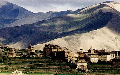 Dolpo is located inside the Shy – Phoksundo National Park of mid–western Nepal, behind the Dhaulagiri massif, towards the Tibetan Plateau. Cut off by a series of very high passes, closed by snow most of the year, Dolpo remains a truly isolated corner of Nepal. Time has stood still here for centuries as the inhabitants of Tibetan stock continue to live, cultivate and trade the way they have done since time immemorial. The finally preserved Eco–system encompasses a wild and wonderful variety of plants and wildlife, including the blue sheep and leopard. A trek through Dolpo is an experience not easily forgotten.
Day 01: Arrival in Kathmandu Airport
Arrival pick up & transfer to Hotel. O/N at Hotel on BB Basis.
Day 02: Full day sight seeing in Kathmandu Valley
Full Day Kathmandu sightseeing Swambhunath temple, BouddhaNath Stupa, Pasupatinath Temple & Kathmandu Durbar square. O/N in Kathmandu
Day 03: Kathmandu to Nepalgunj 165m/541ft 50 minutes flight Take a car to Kathmandu airport and take a 50 minutes flight to Nepalgunj airport. Take 6 km jeep ride to the city in the south. It is about 522km/324mile by road to Nepalgunj takes 16 hours by night bus. It is located south-western of Nepal. Different types of religions are staying here. Nepalgunj airport provides the flight to Dolpo, Bajura, Safebagar, Rukum, Surkhet, Jumla, Surkhet, Simikot and Kathmandu. It is a warm city when summer the temperature grows up to 42 degree Celsius. Over night at Hotel.
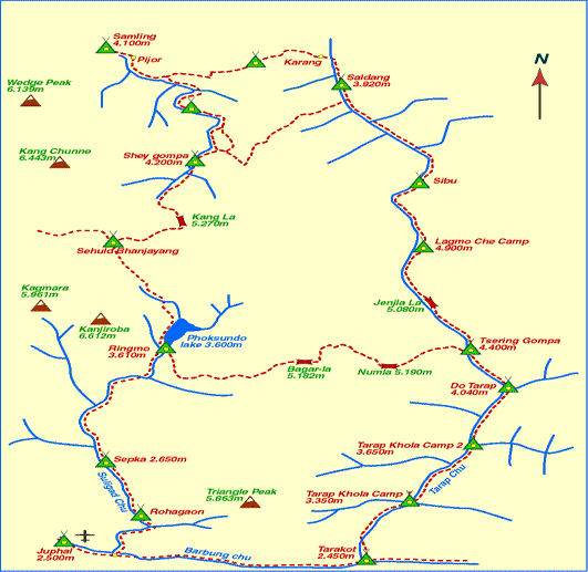
Day 04: Nepalgunj to Juphal 2320m/7611ft and trek to Dunai 2110m/6922ft -3 hours After breakfast drive to airport. Then take flight early in the morning with an arial view of snowcapped mountains, forest, village and rivers to Juphal airport. Start to walk and descend through meadows to reach Kala Gaura 2090m with hotel. Follow the river to reach Dunai.Over night at Lodge/Tented camp.
Day 05: Dunai to Chepka 2670m/8760ft -7 hours After breakfast trek start to cross a bridge and turn west then follow bank of Thulo Bheri and meet the Suli Gaad 2070m then follow east bank of this river. Walk continues to reach Raktang 2260m then cross to west bank and reach a ridge with Goths then cross a bridge and walk continue to reach Ankhe Khola 2460m. After walking some ups and downs you will meet the trail junction and choose the trail leads to Phoksundo Lake and reach a ridge 2710m. Now descend with rocky trail to reach Chepka with shops and lodges. Over night at Tented camp/Lodge.
Day 06: Chepka to Renje 3010m/9875ft -6 hours After breakfast trek start to uphill reach a ridge then cross west side and return to east side. Walk with rocky trail and take more ups and downs through forest of larches and fir. Continue walk and cross a bridge over stream to reach Renje. It is situated across the river and there are several houses. Over night at Tented camp/Lodge.
Day 07: Renje to Ringmo 3735m/12254ft –7 hours After breakfast trek start through Suli Gaad valley with steeper and narrower trail and ascend to reach a ridge and descend to cross a bridge. There are ups and downs and arrives a confluence of Pungmo Khola and Suli Gaad. Take a west bank of the river and climb through forest of cedar, pass campsite then reach to Palam 3710m. Take an entry of check post and descent steeply and climb again to reach a ridge 3780m with a view of 167m long waterfall (Suligad). Descend with forest of birch to reach Phoksundo Khola and climb gradually to reach Ringmo village with typical houses, Mani walls and chortens. Continue walk to cross a bridge and take a south east shore of the Phoksundo Lake. Stay over night at designated camp site by National Park. Over night at Tented camp/Lodge.
Day 08: Rest day at Ringmo village 3735m/12254ft Visit and explore here about Phokundo Lake 3615m, White Pal Sentan Thasoon Chholing Gompa and Ramshackle Bon-Po Gompa. There are few private gompas too. Over night at Tented camp/Lodge.
Day 09: Ringmo to Chunemba 3630m/11909ft – 6 hours After breakfast trek start from southern end of the lake with rocky trail. Cross a stream then see a glacier view of Kanjeralwa 6612m. Climb to a crest 4060m with a view of the lake and peak of Sonam Kang. Descent steeply dust trail through forest of birch and blue pines the the westernmost edge of the lake. Now head west arrives wide valley with thron bushes and scrub trees with tributaries of Phoksundo Khola then reach a camp ground with blue pines in Chunemba. Over night at Tented camp/Lodge.
Day 10: Chunemba to Lar Tsa 4120m – 5:30 hours After breakfast trek start thorugh a flat trail to the north glaciel valley. Cross to a east bank of the Phoksundo Khola and continue with main valley and reach Kang Gompa then climb steeply thorugh birch trees trail to reach a grassy ridge with a view of Kang Chunne 6443m and Shey Shikhar 6139m to the west. Walk continue to reach a crest 4200m then descend gently through rocky trail to reach Lar Tsa. Over night at Tented camp/Lodge.
Day 11: Lar Tsa to Mendok Ding 4610m/15124ft – 3 hours After breakfast trek start to cross a bridge and climb to a top 4490m. Continue climb up through a grassy ridge to reach a crest 4640m. Descend gently into Mendok Ding known as flower valley. Climb along a stream to reach a camp site. You will see the blue sheep above the camp. Over night at Tented camp/Lodge.
Day 12: Mendok Ding to Shey Gompa 4310m/14140ft -8 hours After breakfast trek start to the upper part of Phoksundo Khola and turn north toward Riwo Drugdra Peak and follow across the Sehu La (sacred peak) with circumambulation. Climb up to the north to reach Sehu La 5106m then descend to a stream valley with grassy meadow. Climb ups and downs across ridge. Climb steeply with rough trail to reach a crest 5010m and next a crest 4860m. Descend to the Tar valley and continue to reach 800 years old Tsakang Gompa. Now descend through wide trail to reach camp in a large meadow nearby nomad’s hut just below the Shey Gompa. Over night at Tented camp/Lodge.
Day 13: Rest day here Cross the river with Log Bridge and climb to reach Shey Gompa 4390m. There is a big chorten with big monastery field. It is believed, 800 years old gompa with painting and image of Padma Sambhava, Sakyamuni Buddha and Milarepa. There is Tibetan Scroll that mentioned Crystal Mountain and Shey Gompa. Over night at Tented camp/Lodge.
Day 14: Shey Gompa to Namgung 4430m/14534ft – 7 hours After breakfast trek start through Shey Gompa in the east. Climb uphill to reach Shey La pass 5010m. Afterward turn north and descend down. Climb again to reach Namgung. Over night at Tented camp/Lodge.
Day 15: Namgung to Karang 4050m/13287ft – 5:30 hours After breakfast trek start through Namgung Khola valley to reach Karang. Over night at Tented camp/Lodge.
Day 16: Karang to Mugaon 4100m/13451ft – 7 hours After breakfast trek start to descend to reach Torak Sumdo 3670m with the confluence of the Polang Khola and Namgung Khola. Now you cross to the north bank and climb to reach Yanger Gompa 3750m. Walk along the river valley and reach to the camp site near the stream before Mugaon. Over night at Tented camp/Lodge.
Day 17: Mugaon to Shimen 4010m/13156ft – 8 hours After breakfast trek start through river valley. Climb to reach Mushi La pass 5030m. Now descend into Shimen village. Continue walk to reach at camp site avove the village. This is a pasture of the domestic animals. Stay over night at camp in here or Lodge.
Day 18: Shimen to Tinje 4150m/13615ft – 8 hours Today Climb down to the Shimen village 3870m. A walk continues and climbs uphill to reach Pha 4090m. Climb continues to reach camp site in Tinje. Over night at Tented camp.
Day 19: Tinje to Rakpa 4530m/14862ft – 8 hours After breakfast trek start through runway (airport) trail. Here is trail junction 4130m. The high route goes to Tarap. Continue walk southward to reach camp site in Rakpa. It is situated bank of the river. Over night at Tented camp/Lodge.
Day 20: Rakpa to Chharka 4120m/13517ft – 7:30 hours After breakfast trek start to continue uphill to reach Chharka La 4920m. Descend through the side of the valley and climb down hill to the valley 4290m. Continue walk and descend to reach village. It is situated bank of the Barbung Khola. Over night at Tented camp/Lodge.
Day 21: Chharka to Norbulung 4750m/15583ft – 7 hours After breakfast trek start to down hill to the river and follow the right fork southward. Walk through a rough trail with uphills and downhills. It is a narrow valley at first then arrives a big meadow. Now climb to reach the camp site in Norbulung. Over night at Tented camp/Lodge.
Day 22: Norbulung to Sangda Phedi 5460m/17913ft – 8 hours After breakfast trek start to climb uphill to reach Molum Sumna 4860m. It is a yak pasture. Continue climb uphill to reach a crest 5130m. Continue walk through the meadows with the foot of Sangda La. Climb steeply to reach a pass and reach the camp site. Over night at Tented camp/Lodge.
Day 23: Sangda Phedi to Sangda 3700m/12139ft – 8 hours After breakfast trek start to climb to reach a lower part of Sangda La 4990m then descend to reach the village of Sangda Ghunsa 4190m. Climb down to cross the bridge over Chalung Khola 3750m. Now climb steeply to reach a cairn 4090m then descend steeply to a stream 3580m. Now climb to reach a settlement of Sangda for camp site. Over night at Tented camp/Lodge.
Day 24: Sangda to Dhagarjun – 8 hours After breakfast trek start to climb to reach a hill behind the Sangda. You should cross several ridges and reach a last crest 4280m. Now descend to the Annapurna region where deepest Kali Gandaki valley is. Walk through a side of cliff and descend to reach camp site in Dhagarjun. It is a big village with Bhotia people. Over night at Tented camp/Lodge.
Day 25: Dhagarjun to Jomsom 2710m/8891ft – 6 hours After breakfast trek start to Jomsom. Jomsom is famous for apple Brandy. This is windy valley with the view of Nilgiri Peak 7061m. Here is check post, army and police and nowadays road to go back to Beni. Please reconfirm your flight ticket to Pokhara for tomorrow morning. Over night at Lodge.
Day 26: Jomsom to Pokhara 830m/2723ft – 20 minutes You should take an early morning (before 10 AM) flight from Jomsom because of windy valley. There is Twin Otter flight with the view of Dhaulagiri Himalayn peak with glaciers, Annapurna, Ghorepani, Sarankot, Pokhara city with Phewa Lake are beautiful. Over night at hotel.
Day 27: Pokhara 827m/2713ft to Kathmandu 1350m/4429ft – 7 hours by bus Pokhara to Kathmandu is about 204km. 25 minute by flight and 5 hours by car to get Kathmandu. Overnight at hotel.
Day 28: Departure to Tribhuban Internationl Airport . After breakfast Departure transfer to Airport for your onward destination.
• All necessary private transportation.
• Kathmandu sight seeing with experience English speaks guide.
• Hotel accommodation with twin sharing basis on BB (Bed & Breakfast) in Kathmandu/Nepalgunj and Pokhara.
. Air fare Kathmandu-Nepalgunj-Juphal-Jomsom-Pokhara-Kathmandu
• Accommodation in tent on twin sharing during trekking.
• An experience English speaks Trek Guide & porter during Trek.
• Dolpo/Annapurna Conservation Permit for upper dolpo trek.
• All camping gears, cook, Sherpa, helper, tents and fuels for camping trek or Tea House Trek.
• Breakfast / Lunch / Dinner & tea / coffee during trek.
• Down Jacket and Sleeping Bag that should returned to office after trek completion.
• Medical Kitbag for trek.
Cost does not includes:-
• Visa fees.
• Insurance including evacuation.
• Lunch and dinner in Kathmandu, Nepalgunj and Pokhara
• Airport tax National & International.
• Bar bills, lundary, hot shower in the mountain if ask and other expenses of personal nature.
• Tips for guide and porter that normally expected in Nepal.


Connect With Us :